The Data Preparation menu consists of two sets of tools. The first focus on Survey Preparation of topographic surveys:
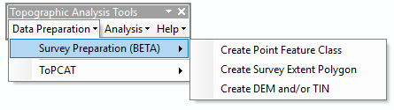
This includes:
- Create Point Feature Class Creates a shapefile from a point cloud file (e.g.
*.pts,*.xyz, etc.) - Create Survey Extent Polygon Creates a bounding polygon around a survey point feature class
- Create DEM and/or TIN Creates a TIN and derives a DEM from that TIN
The second set of tools simply allow a user to run ToPCAT to process large point clouds within a GIS environment and visualize the outputs in GIS.
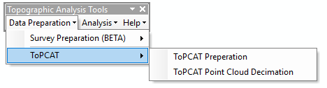
This includes:
- ToPCAT Preparation Ensures that your input point cloud file is in a format that ToPCAT can read
- ToPCAT Point Cloud Decimation Runs ToPCAT on a point cloud
 Back to TAT Home